
Feb 20 - Sea to Sky Snow Conditions
Overall theme:
Pattern change! If you’ve been outside the last two days, you’ve definitely noticed - it’s RAINING! Hallelujah! We’ve been in a pretty serious drought so it’s nice to have some substantial precipitation to talk about. Sure, it’s not great for low elevation skiing at the moment but let’s see where this storm takes us!
Where we’ve been skiing:
All through the corridor! Sea to Sky Gondola, Brohm, Whistler Blackcomb, Currie, Duffey and up the Hurley. We noted a big range in snowpack depths throughout the corridor prior to our current storm.
Height of Snow (HS) at Treeline was:
- S2S Gondola: 360cm
- Whistler Blackcomb Alpine: 320cm
- Whitecap Lodge: 160cm
Low elevation access has been decent with most trailheads skiable however we’ve been slowly losing snow in valley bottom. Our yards in Squamish are officially snow free now. Alpine continues to fill in VERY slowly and remains pretty rocky in steep terrain but the current sludge getting laid down will help. Overall the skiing has been quite good as the upper snowpack continued to facet out.
We will probably see a corresponding difference in precip totals with a rough forecast of:
- 97mm on the North Shore
- 58mm at Whistler Blackcomb
- 37mm at Blowdown (East Duffey)
What’s happened since the last update (weather & general snowpack structure):
This past weekend we saw new snow fall with wind. Sunday was particularly touchy with several windslabs triggered at the Sea to Sky Gondola. It’s very likely some of these slabs failed on buried surface hoar. With the amount of faceting though, we didn’t see quite the avalanche cycle we might have expected. A factor might be that while we have the weak layer (the facets), we don’t have a strong bed surface, like a melt freeze crust, for an avalanche to run on. The facets have good progressive resistance and we saw more of a loose dry problem than anything!
Of course, this is all changing with our current storm. 30mm of precip fell around Squamish on Wednesday. This would have been primarily rain below 1500m and primarily snow above. At all elevations, it’s a high density snow load and it’s falling with strong wind. This is a great recipe for overloading the weak layer and seeing an avalanche cycle!
Our snowpack is a little more interesting than it has been previously:
- The lower snowpack is pretty unremarkable. Not even much for crust layers! Just homogenous snow.
- Jan 30th layer is the long dry spell. This snow fell on facets then the new snow faceted out OR blew away.
- Feb 15th layer is last weekend’s storm. This was initially quite reactive (possibly a SH issue?) then tightened up with warming/cooling cycles. We found well preserved surface hoar below treeline today. This didn’t have time to facet out and now it’s getting slurped by the current storm, a classic Pineapple Express.
What’s the weather and avalanche forecast?
It’s stormy! An active west to southwest flow will bring a series of frontal systems across southwestern BC this weekend.The first system is expected to reach the area on Friday; the second system will arrive on Saturday spreading heavy precipitation across the area with the freezing level rising to near 2000 m by Saturday afternoon in the system's warm sector. This will have a deep plume of moisture aimed across the area from the subtropics towards the coast, so expect heavy rain below the freezing level with snow on the highest elevations. The third system will arrive on Sunday; this system will also have a subtropical tap with the freezing level rising to near 2000 m.
Forecast Summary:
- Friday: Strong Southwesterly with Freezing Level at 1500m and 20cm expected.
- Saturday: Very strong southwesterly with FL 1500 rising to 2000m and 20-30cm expected.
- Sunday: Very strong southwesterly with FL 1500 rising to 2000m and 20-30cm expected.
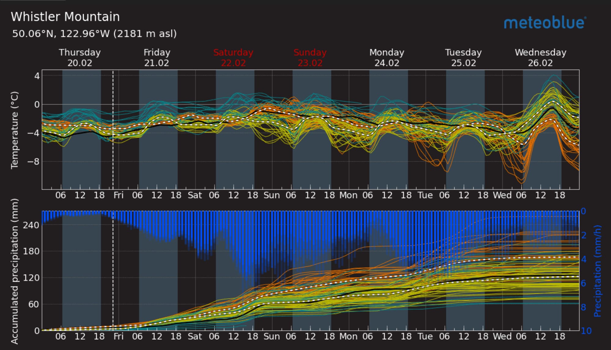
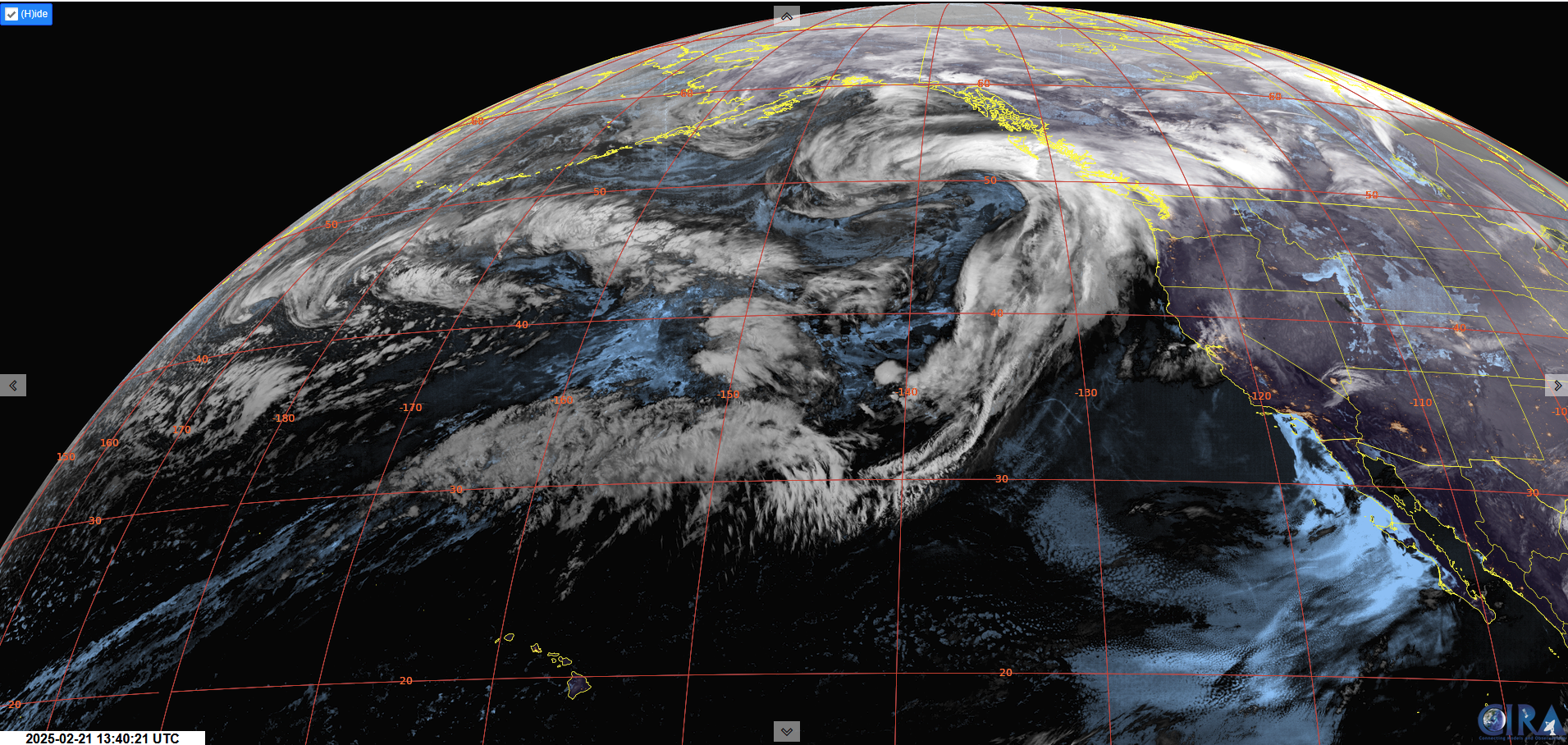
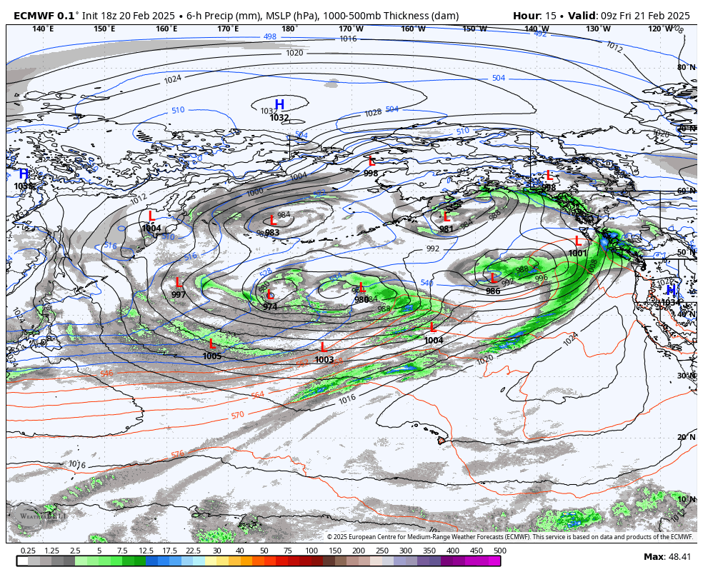
Meteoblue Multimodel forecast for Whistler (L). ECMWF model showing a series of systems with an atmospheric river setting on Saturday (R).
The avalanche forecast on Avalanche.ca reflects these big storm loads with hazard increasing to High at Alpine and Treeline on Saturday. This hazard level is expected to continue through the weekend and into next week as long as the precip continues to stack up. This will be a storm slab problem for the most part but we may see wet loose avalanches reach lower, below treeline, elevations.
What are my questions for the weekend?
Where will that freezing level settle? Thursday afternoon we saw a break in the weather and there was snow in the trees around 1200m (which has seemed to be the magic number pretty often this season). On Thursday night and Friday morning, the freezing levels fluctuated significantly between 1000m and 1400m.
Which areas will get loaded enough for a clean out (likely the North Shore) and which areas won’t get enough load (East Duffey)?
What will I watch out for or avoid completely?
- I’ll be steering clear of avalanche terrain on Friday, Saturday, and possibly Sunday as well. If it’s possible to get out and above the rain, low angle terrain right at treeline without overhead hazard will be the play. You need to get above the rain line but not so high you don’t have vis.
Closing Thoughts:
It’s not inconceivable to think you could find good skiing this weekend but it will require some threading of the needle. The ski resort might be a really good option to milk those elevation bands, especially mid-storm. There’s also always a chance the snow line dips a touch and that could provide some really good tree skiing. You certainly don’t know unless you go! We’re fully stepping back from send mode earlier this week and into storm mode for a bit here. Embrace it and dream about the stability to come.
For more information, check out Zenith Mountain Guides and our local avalanche forecast. Weather forecasts are custom from meteorologist Jason Ross. These updates are supported by SkiUphill Squamish - the best stop for ski touring equipment in the Coast Mountains and made possible by the Sea to Sky Gondola! Use this information at your own risk. Conditions change rapidly from when this report was written!
Member discussion