
Jan 30 - Sea to Sky Snow Conditions
Overall theme:
Pattern change incoming! Our last measurable precip in Squamish was January 10th! That means we’re going to be talking more about what’s about to happen than what’s been happening!
Where we’ve been skiing:
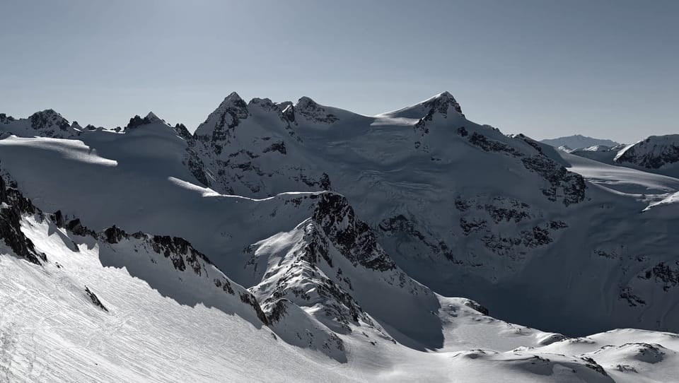
Whistler Blackcomb and the Duffey. The ski resort has been rugged. We’ve been trying to follow our own advice. The best snow for turns has been deep in the Duffey where we try to get away from existing tracks and stick to a narrow elevation band at treeline on sheltered polar slopes. Closer to the Coast, conditions have been better for travel than actual skiing. Eric did the Spearhead Traverse on Wednesday before the weather moved in and conditions were thin but good for moving.
What’s happened since the last update (weather & general snowpack structure):
The Sea to Sky in general has been pretty quiet for avalanche activity. Winds have been relatively light, temperatures moderate, and no new snow. The biggest thing has been a temperature inversion and sunny days. We’ve seen a bunch of wet loose avalanches earlier this week but they mostly have been in steep, rocky, solar terrain that generally wasn’t seeing much skier traffic. A few cornice falls have been reported but for the most part, they aren’t huge right now and the cold/warm cycling has kept them small. Eric saw a relatively large (Sz1.5) cornice failure that likely occurred Tuesday or Wednesday on the Spearhead passing by the usual spot on Overlord. This is all likely to change on Friday!
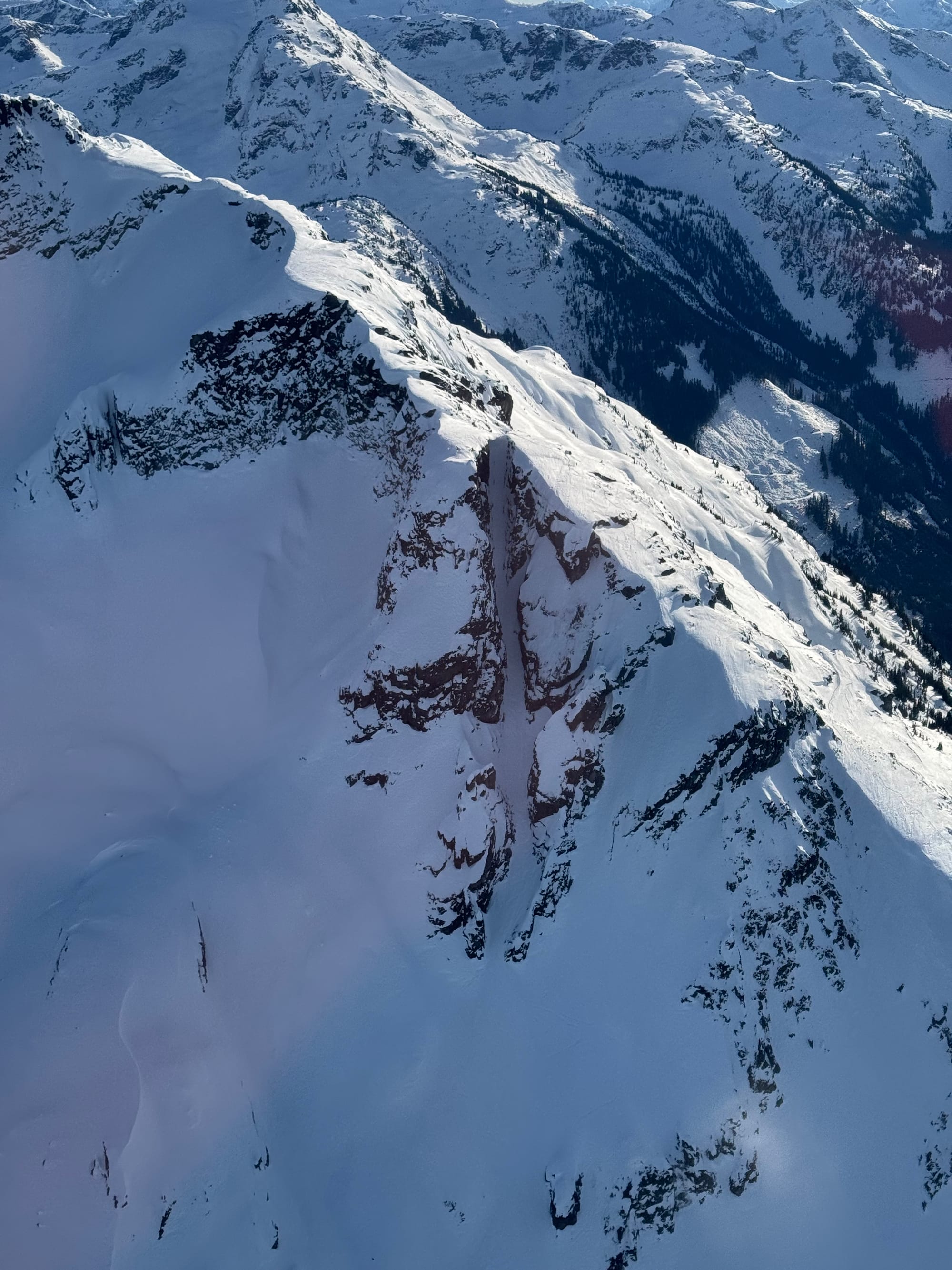
Currie NF (L) and Duke Couloir (R) looking boney!
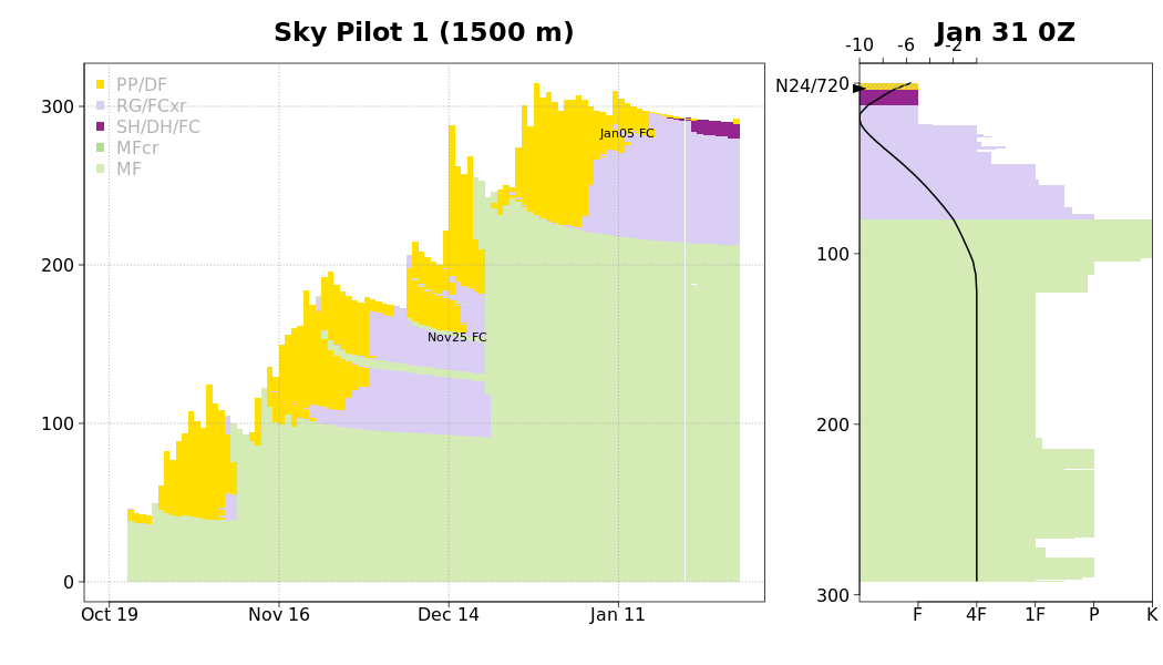
Snowpack structure is currently very simple but it’s about to get complicated. The mid and lower snowpack is well consolidated and has no layers of concerns. It’s bomber and well settled.
It’s the surface snow we have concerns with. In solar terrain, we have a generally supportive melt-freeze crust that has been slowly faceting. On polar aspects in higher/exposed terrain, we have a mix of wind pressed sastrugi, wind board, and breakable crust. In sheltered terrain and closer to treeline, polar aspects hold preserved snow. Anywhere that has had skier traffic is becoming quite firm.
All of these surfaces are experiencing significant faceting and it’s possible to find facets 15cm to 30+cm deep. These crystals feel really “sugary” and fall through your fingers like sand - you can’t create a snowball. This layer of weak facets will be buried by the incoming storm and pose a problem this weekend and potentially through the rest of the season! To add to this, we’re getting a decent mid winter W-NW Flow storm, which means colder and drier snow. Great for snow quality but worse for the onset of the precip to bond to the old surface with typical warmer temps.
What’s the weather and avalanche forecast?
The good, the bad, and the ugly! A frontal system will push on to the BC Coast with heavy snowfall over the alpine through this afternoon. Total storm snowfall amounts of 30-60 cm are expected over the Sea to Sky mountains by Saturday morning. An upper low will slowly slide southwards along the BC this weekend, resulting in unsettled conditions with convective flurries at times. The upper low will help usher in much colder temperatures into early next week with strong outflow winds developing as an arctic ridge of high pressure builds over the BC interior. Key message heading into next week is to bundle up as there is a risk of frostbite with alpine temperatures expected to drop below-20 to -25 Tuesday to Friday!
- Friday: Strong SW wind with FLs near 100m and 30-60cm precip.
- Saturday: Moderate to Strong SW wind with FLs dropping to valley bottom and 5cm new snow.
- Sunday: Strong outflow wind (N) developing in the afternoon, freezing levels in valley bottom and 10-20cm of new snow.
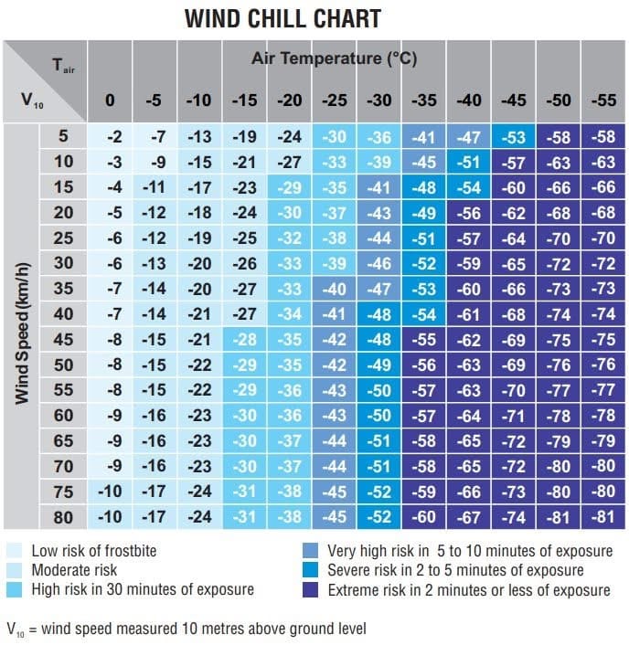
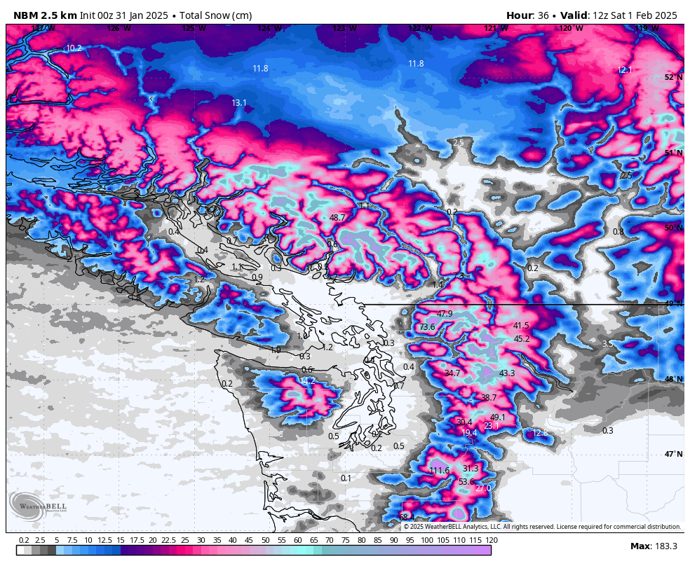
Keep frostbite in mind as we go into next week! Right: National Blend Models total Snowfall amounts by Saturday morning at 4 am PST.
The current avalanche forecast is for High hazard in the alpine and at treeline with Considerable hazard below treeline. This may persist through the entire weekend and into next week. We anticipate an avalanche cycle on Friday and continuing through Sunday as the storm progresses. Avalanches will occur naturally on all aspects and run into terrain where we haven’t seen avalanches in some time.
Looking further ahead, we will see natural avalanches taper off however it’s likely that areas will remain touchy to human triggers for some time. This will require careful evaluation of hazard and cautious terrain use. The weak facet layer that’s buried this weekend will likely persist in certain areas until we get another storm that can trigger a large natural avalanche cycle. Best case for us right now would have been a storm that starts with rain and then a huge load of snow. Instead, it looks like we’ll be getting a cold storm that will drop moderate amounts of snow. This won’t be a total wipeout and reset but instead will leave us with some serious concerns in the snowpack.
Even further into next week, we’re expecting a quick reversal back to a strong arctic outflow. This will mean strong winds from the north and all that new snow we’ve been desperate for is going to be stripped and redistributed. Whew - what a rollercoaster!
What are my questions for the weekend?
- How much snow? At the moment it looks like 20-50cm for the corridor. Models aren’t super tight so it’s a big range. We’ll see what we get and what that translates to for an avalanche cycle. The drier places might just barely reach threshold amounts for critical loads - with winds/wind loading throwing them over the top. This would be interior Duffey and Hurley type locations.
- How much of an avalanche cycle will we see during the storm? The more avalanches that happen naturally during the storm the better. We want to wipe away that facet layer and not have any residual hazard.
- How much residual hazard (human triggerable) will exist after the storm? At the moment, it seems like this will be an issue. Be very careful of avalanche terrain that did not clean out in the storm or even perhaps have been reloaded. We’ll also have the standard storm/wind slab to worry about on top of the persistent weak layer.
What will I watch out for or avoid completely?
- We will likely be avoiding avalanche terrain on Friday and through the weekend. As we see natural activity taper off, we’ll consider how we feel stepping out into avalanche terrain.
Closing Thoughts:
We’re excited for the new snow too but temper that enthusiasm until the community has a better understanding of the instabilities we’ll be dealing with. If we have important new information, we’ll consider a weekend newsletter update. Low angled terrain below treeline will be the first place to explore but it’s also going to be great XC skiing this weekend!
Also - Eric just uploaded a video with a review of the current Dynafit boot lineup. If you're interested in the Ridge or Tigard, or just want to dork out on touring boots, give it a watch on YouTube!
For more information, check out Zenith Mountain Guides and our local avalanche forecast. Weather forecasts are custom from meteorologist Jason Ross. These updates are supported by SkiUphill Squamish - the best stop for ski touring equipment in the Coast Mountains and made possible by the Sea to Sky Gondola! Use this information at your own risk. Conditions change rapidly from when this report was written!
Member discussion