
March 14 - Sea to Sky Snow Conditions
Overall theme:
Please bear with Eric this week. The winter’s weather has had him on an emotional roller coaster this year, and just as things were looking amazing - albeit tricky with snowpack layers - Warmaggedon arrived…
It’s weather forecasts like this that make Eric wonder what he did in a past life to get this kind of karma. Perhaps all this time cursing the sun, we’ve just been angering the sun god Ra. Well we repent and now pledge our souls to Ra in the hopes he will give us a reprieve until June…

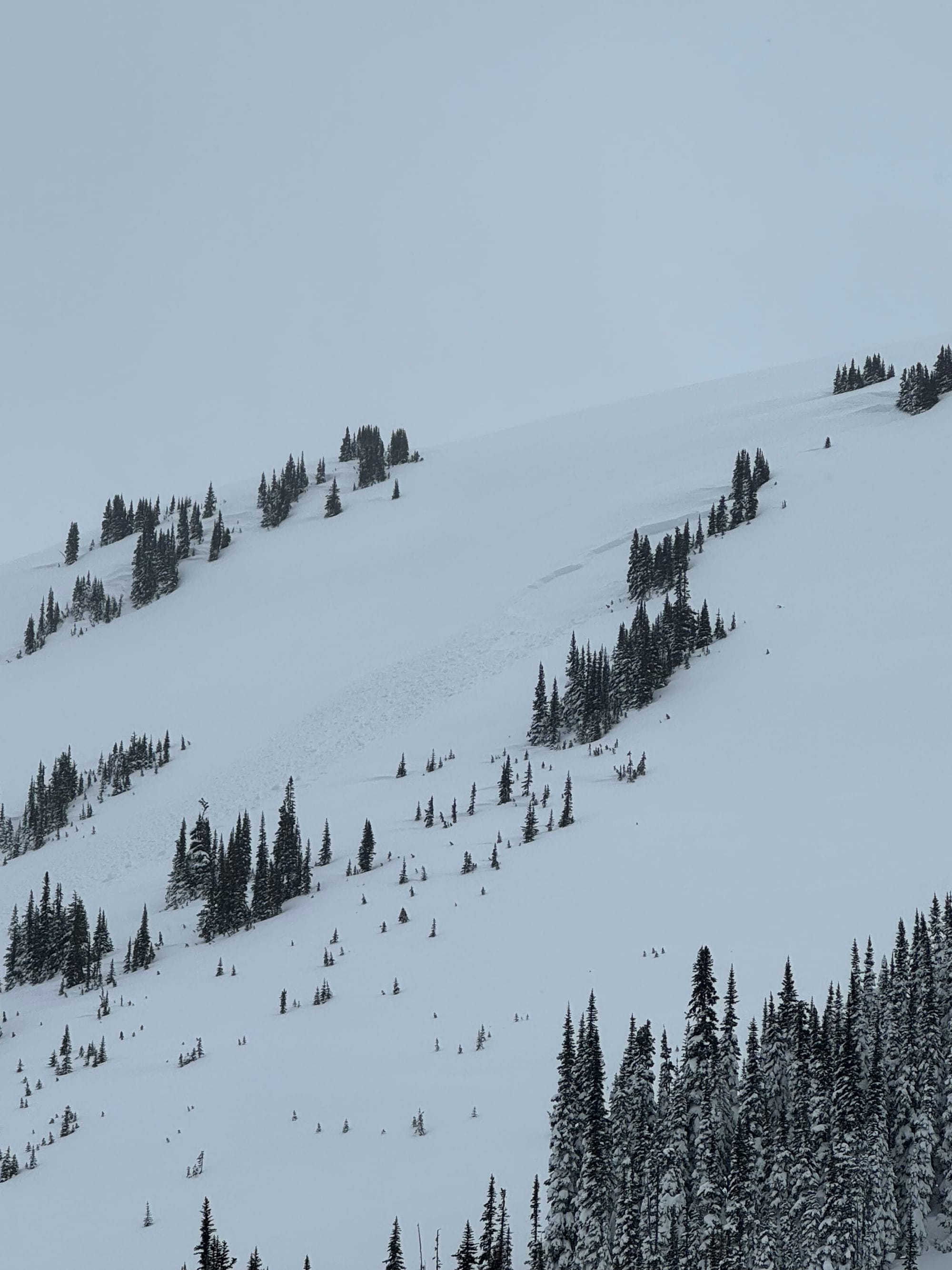
In the meantime, if you haven’t already noticed that you’re currently wearing a t-shirt, it’s going to be warm this week. Very warm. Warmer than we can imagine. First, let’s look back on last week though. The storm arrived Friday and continued dumping snow through Tuesday. In Squamish and Whistler this fell on a *relatively* well settled snowpack but one of our main questions last week was if the snow load would be enough to crush out the existing instabilities. That turned out not to be the case: natural and remote triggered avalanches were reported throughout the week. These frequently stepped down to our old friend the early February crust that has become a persistent weak layer.
Our second question was if we’d see surface hoar development before the snow fell. Yep - we did. And it’s all over the place! This contributed to the instability above and likely was the failure layer for many avalanches.
Where we’ve been skiing:
We have been out this week in Squamish, Whistler-Blackcomb and the central Duffey. Each day has been primarily in assessment mode and certainly not stepping into bigger, more complex terrain. We’ve seen limited terrain but also seen firsthand how the snowpack goes from thick to thin as you move north through the corridor and how the reduced snow load increases the reactivity.
What’s happened since the last update (weather & general snowpack structure):
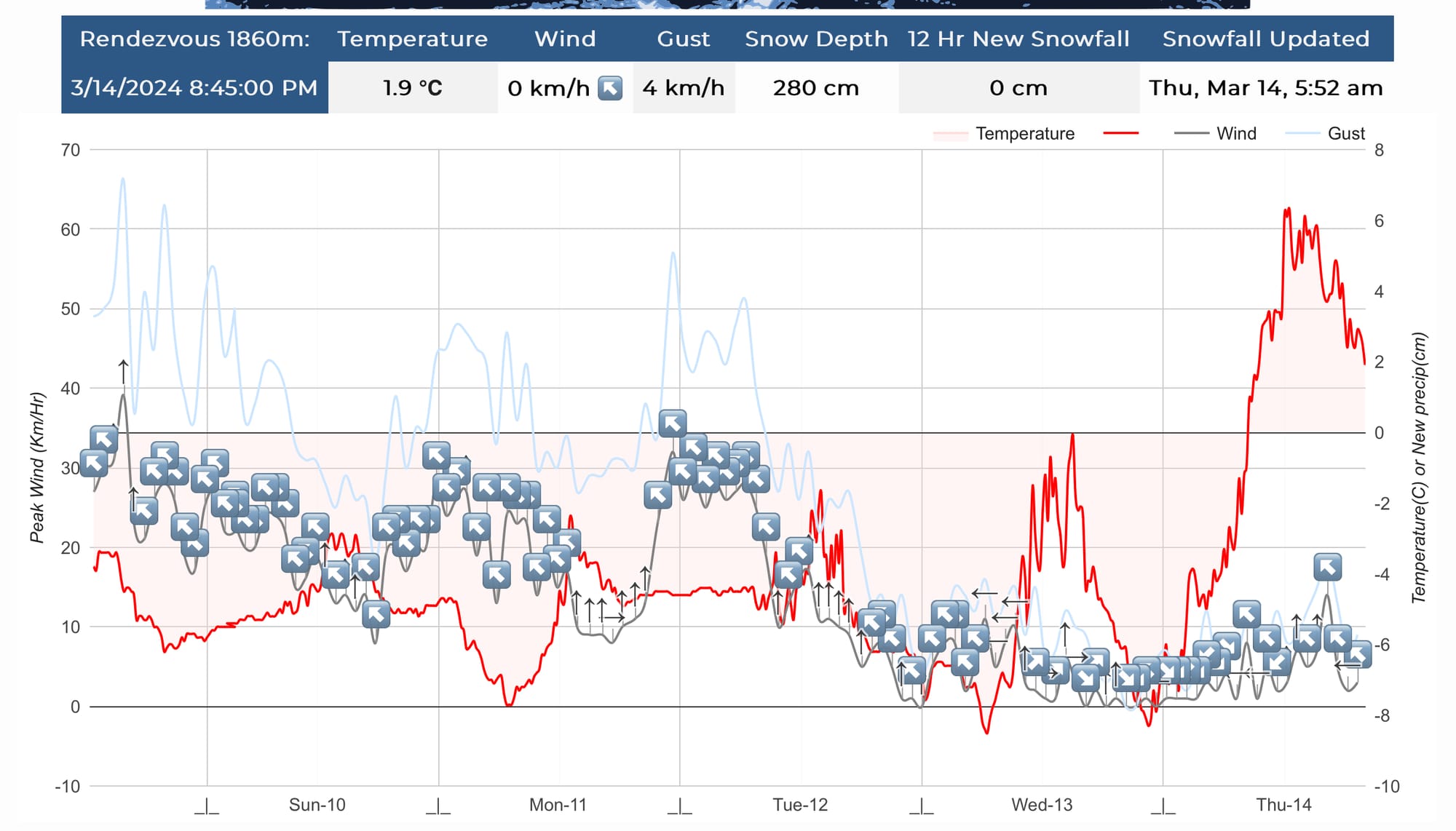
Snow started on friday and continued through the weekend. By Tuesday, 135cm had fallen at our snow study plot at the Sea to Sky Gondola (1050m). Whistler reported ~140cm during the storm, and on the Duffey, storm totals were 60-80cm. All this snow was distributed by extreme winds from the south and southwest. This is in contrast to our storm the previous week which was nearly windless!
The wind did likely help blast away some of the surface hoar that formed before March 8th but judging from how reactive the snowpack has been, it’s likely that the surface hoar was preserved in many areas that were slightly protected. Below the storm snow and surface hoar, you’ll find the previous week’s storm snow sitting on the early February crust that is covered in facets. The facet layer is again thinner near Squamish and much thicker and more pronounced on the Duffey with concerning (sudden collapse) snowpack tests failing on this layer.
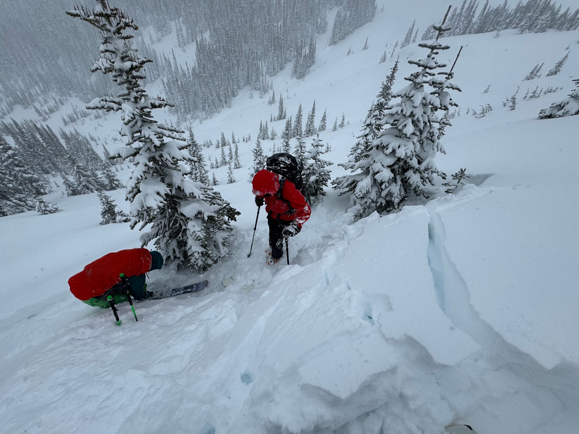
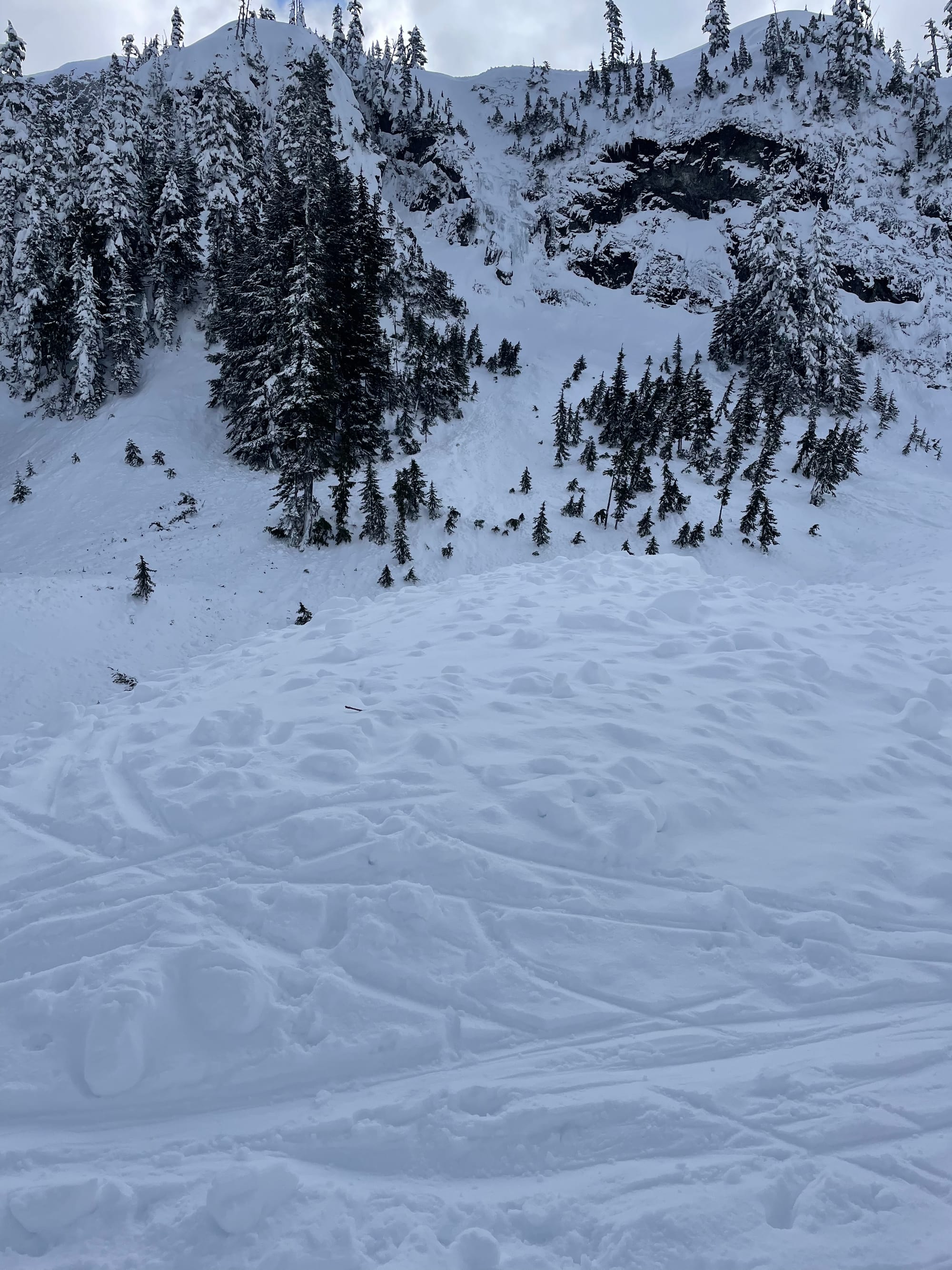
Lots of cracking and numerous skier accidental and skier remote avalanches on the Musical Bumps early in the week. (Jack Casey Photos)
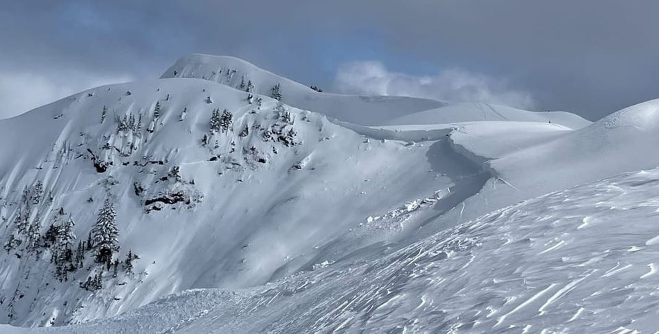
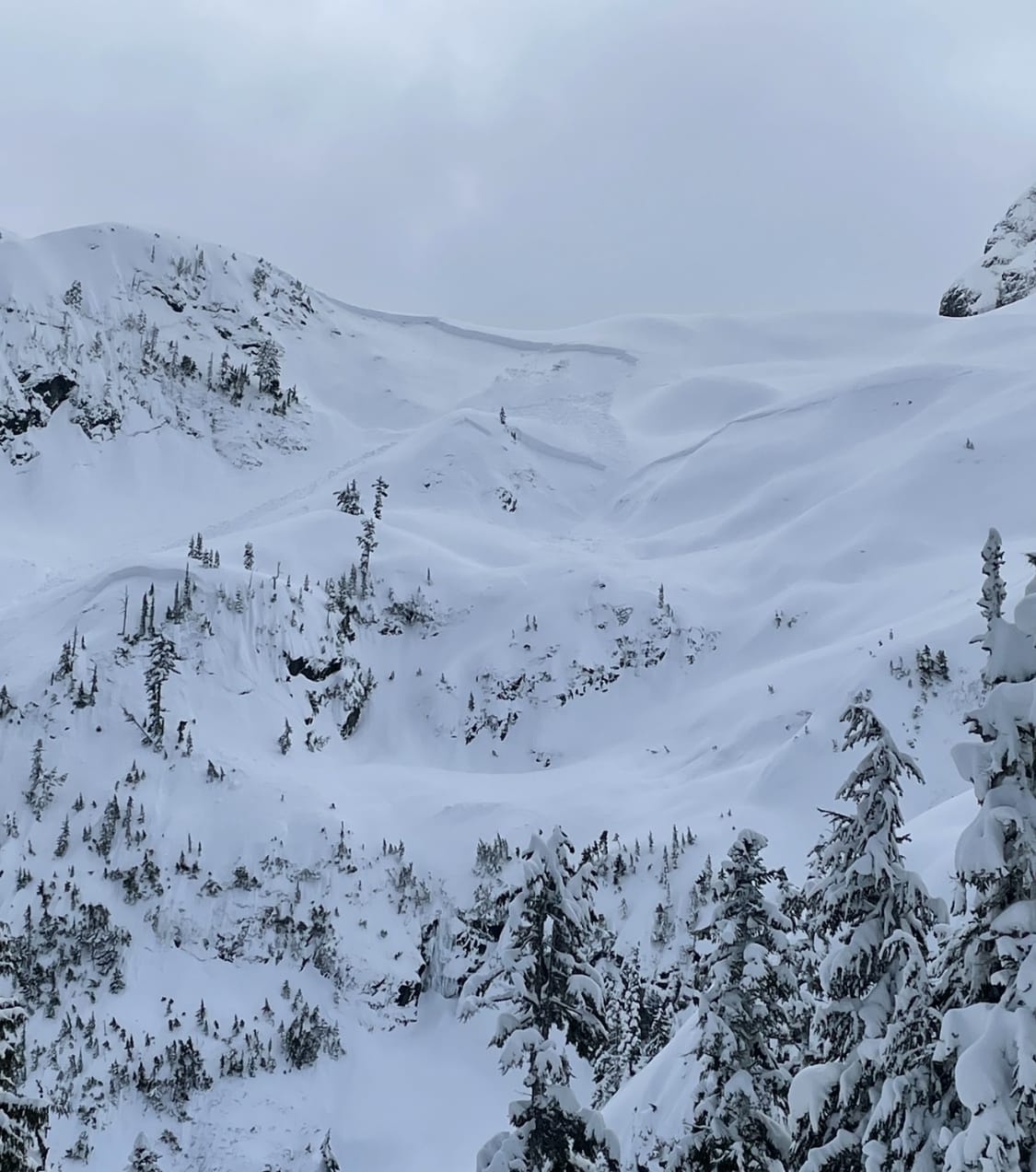
Even in Squamish, large avalanches occurred. A number of parties took advantage of the only day that danger was below high to get up the Sea to Sky Gondola on Wednesday and found evidence of a size 3 natural slide that ripped out at the tail end of the storm (early in the week). This spot is a repeater that has already slid big this summer. Concerningly however, this time the debris crossed the normal skin track that is used to access the Stadium area. This should drive how just how complex the terrain is around Shannon Creek. As soon as you turn and skin up the Sky Pilot Valley Road, you enter avalanche terrain. As soon as you leave the road and skin up towards treeline, you enter areas with multiple overlapping avalanche paths that cannot be avoided!
What’s the weather and avalanche forecast?
At least this part is easy. For the 7 day forecast, we have freezing levels of ~3500m, so a daytime high of +5 to +8 deg at 2000m and overnight lows of around 0 deg. Wind will generally be calm and the sky will be clear. It’s going to be beautiful at least!
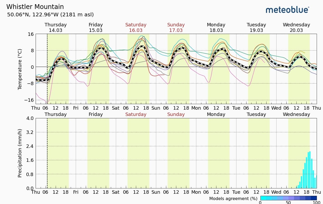
Avalanche danger will be high at all elevations with the chance for numerous large destructive avalanches. Large avalanche cycles can create new slide paths in old forest and surprise not just ski tourers but also snowshoers and hikers below treeline. This may taper off with repeated days of heat but really we don’t know. Overnight radiative cooling will help tighten up the snowpack somewhat and may be our saving grace but the forecast through the weekend is with limited overnight cooling. As we type this on Thursday night we are hitting our alpine high temperature at 9pm of +3 to +5 and it will likely stay there. This is indeed a huge part of the problem. We are not really cooling overnight. These transition times to spring snowpacks do not happen quickly and as soon as we have any free water percolating through the snowpack, that will hit our Facet/crust layer and light it up for activity again.
What are my questions for the weekend?
We had a pretty interesting “mid-winter” snowpack with nearly 2-3 meters of unconsolidated snow. That’s all going into the microwave on high for the next week or more. What the heck is going to happen? Almost certainly, any instabilities will be triggered and form very large, destructive avalanches!
What is going to happen after this week? It does look like it will eventually cool back down in the 10-day forecast. At this point it’s tough to speculate but some model runs are consistent with this winter heat dome getting pushed away on the 20th/21st. Fingers and toes are crossed for that to happen. Perhaps even with a bit of snow. As long as we don’t lose the entire snowpack (please no rain) - we may be back to spring skiing after that! Say your prayers to Ra that we’re allowed a little more winter before he takes over for the next 9 months…
What will I watch out for or avoid completely?
Avalanche terrain. In fact, almost any backcountry terrain this weekend. I don’t want to be in the vicinity if we do have a historic avalanche cycle. Even if it feels like good safe forest, we don’t know for sure what’s above. Eric will be rock climbing and working on his house until things cool back off. The exception might be some cross country skiing at Callaghan in the sun. Evan will not be operating in any avalanche terrain at all. There’s not a single objective out there that is worth the risk right now. Remember earlier this season when Evan discussed how weird weather means weird avalanches? When was the last time you saw 2-4 meters of snow fall on a widespread, well developed crust with prominent facets on it followed by record breaking heat…?
And let's not forget that we actually have tons of fresh, weak cornices from strong S-SW winds that will roast in the sun to further add to our tenuous situation. Fun times!
Closing Thoughts:
Simply, be careful. It’s not a week for exploring or peak bagging or traverses. The snow conditions are sticky and terrible and the avalanche conditions should be terrifying. Take it easy! We’ll see what comes on the tail end of this but hopefully it’s cooler temps and some precip!
We recently had an interview with an interesting new ski touring website called The High Route. They’ve got some cool content on gear, techniques, objectives, and other interesting ski related stuff.
Tune in next week for the next twist of our rollercoaster and more tips on how you too can appease Ra!
Eric Carter and Evan Stevens contributed to this report. For more information, check out Zenith Mountain Guides and our local avalanche forecast. These updates are supported by SkiUphill Squamish - the best stop for ski touring equipment in the Coast Mountains and made possible by the Sea to Sky Gondola! Use this information at your own risk! We are not responsible for your actions in the backcountry and conditions change rapidly from when this report was written!
Member discussion