Nov 21 - Sea to Sky Snow Conditions
Overall theme:
What a week it’s been! Tons of snow, new zones opening, and LOTS of psyched folks getting after it! We’ve got more snow on the way and perhaps some sun coming later in the weekend so read on. We’re back to our winter format for our snow conditions updates. We hope you enjoyed the articles we’ve had the last few weeks and we’ll still sprinkle a few of those in as we go!
If you attended any of our SkiUphill Snowpack Discussion nights last year, we have exciting news - we’re starting up again for this season with our season opener the evening of December 6th and it’s going to be hosted up at the Sea to Sky Gondola Summit Lodge!
Come out for a snowpack talk, some dinner, a film, a bit of a party and lots of fun stuff and prizes! We’re limited to 100 folks and tickets are cheap (all proceeds donated to Squamish SAR). The S2SG has even offered super discounted lift passes for those folks who don’t have passes. Click the link for all the details and to grab a ticket!
Where we’ve been skiing:
We’ve been out at the Sea to Sky Gondola, Paul Ridge, and everyone and their uncle has now made it to Whistler/Blackcomb! Access has just started to improve with the low freezing levels of the ‘Bomb Cyclone’ that the media loved to hype. Let’s just clarify that this is an improved status and it’s still mid November - we have a long way to go! For the most part this still means avoiding below treeline elevations and favouring the best access options to get there. Logging roads and well established trails are still your best bets.
Here’s the run-down on a few local spots:
- Paul Ridge: Its chain season. Put them on. The road is going through freeze thaw and it's a slippery mess. You can now ski and skin from the car! There's a solid 20-30cms of packed snow on the access road.
- Sea to Sky Gondola: closed until the 29th. Further they have closed the road behind the Chief full time for the next 10-14 days as they try and finish off the powerline project along the road. If you really need to ski up there now, hike the trail from the valley with your skis on your back - yes that’s the only way! Cars, bikes, sleds will be turned around from the road. Don’t hassle these guys - they’ve got good stuff in the works for ski tourers!
- Mamquam/Indian Arm FSRs: restricted access these days too. This means Mulligan/Anif is full time closed for the foreseeable future - with a massive yellow gate that you can not get around. Tree falling, blasting, etc is going on up there for the Fortis Pipeline project so no public allowed.
- Garibaldi Park via Rubble Creek: getting hiked/skied a bit. It's a long walk to Black Tusk/Panorama ridge but it's a great early season choice.
- Shovelnose: still a great early season option, but you’ll be parking low down now without a sled. I imagine it's rugged, chained-up 4x4 to get to 800m of elevation to start your day. Be prepared and also be prepared that sleds may start accessing that terrain more heavily.
- Brandywine: Powder Mountain Snowmobile Club began grooming their roads from down low - no more high driving access! Never (ever) drive on groomed roads!
- Whistler/Blackcomb: now open but its early season and access to the high country will be similar to every year. Obey no-uphill access signs, they blast and have lots of machines around all times of day. From experience I’d say the best bet is to slide down from top of Jersey Cream to base of 7th heaven chair and access via Decker Meadows/Body Bag bowl. I think folks were skiing out Spanky’s and such in bounds thursday, meaning there might be access out of Blackcomb glacier via rescue road - but typically this means no access to Blackcomb glacier from Hortzman- you’d have to come around from Bodybag or Decker Meadows.
- Duffey: A few reports from Steep Creek zone look thin but doable. Total snow depth is 35cms at the road, and 75cm at 1900m on Blowdown. Maybe it's 1m at TL on Cayoosh? But getting there with these numbers would not be much fun at all! I’m going to give it one more decent storm cycle…
What’s happened since the last update (weather & general snowpack structure):
- Snow, snow and more snow. Lots of varying amounts, that is typical for us. And surprisingly Whistler has been receiving a ton of new snow with some of the highest settled snow amounts around. 130cms at 1500m and maybe close to 160cm up at 1800m. 80cms since the 15th! From my obs, snow amounts have been similar throughout the corridor.
- Wind: lots of wind has been accompanying these storms, and that's not a bad thing as it really fills in the lines. We’ve had some warm storms early-season so things feel decently covered despite the winds. You can feel some old slabs in the snowpack, but the warm temps and constant snowfall has worked to settle them out within 24-48 hours.
- First few avalanches of the season! We did have a small cycle during the week due to shallow surface slabs from rapid precip rates and in some areas a small surface hoar layer that was buried. There was a bit of overnight reactivity on the 18/19 but that was all settled out by Thursday.
What’s the weather and avalanche forecast?
An area of low-pressure will deepen off Vancouver Island,bringing multiple fronts to southwestern BC today through early Saturday, causing precip and gusty winds in the alpine! 20-30cm are expected from Friday to Saturday morning with strong wind, and 5-10cm by Sunday morning.
By Sunday, a high-pressure ridge will build over northern BC, clearing skies and bringing light wind and drier conditions into next week. Freezing levels will fluctuate: 1000m Friday, rising to near 1500m Friday evening, and lowering back to near 1000m Saturday and Sunday.
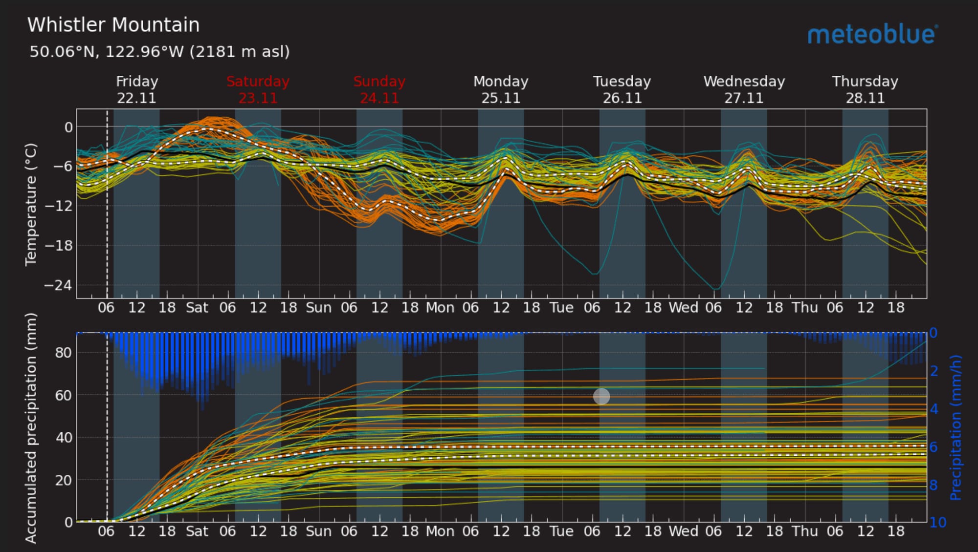
Higher precip amounts are expected on the north shore and near Howe Sound. This is reflected in the avalanche forecast with AvCan calling the danger high in the alpine and at treeline during and after Friday’s storm.
-Weather forecast provided by Meteorologist Jason Ross
What are my questions for the weekend?
- Are we in avalanche terrain? It’s time to fully switch to a winter mindset. We have reached threshold amounts for avalanches in the Alpine and many Treeline locations. Below treeline open slopes are borderline in many places. If you’re on some smooth surface snow with no discernible ground roughness - get your avalanche game on!
- What avalanche activity will we see in Friday night’s storm? This is the old “what flushed in the storm” game! Paying attention to which paths slide and which ones accumulate load is critical to understanding how terrain reacts throughout the season.
- What will next week’s high pressure do? We definitely prefer it just continue dumping down snow this time of year but it’s also certainly nice to get up high and be able to see the alpine! We’ll be keeping an eye out for surface hoar which will almost certainly start building with cold days and nights. The big question will be if the SH is preserved and buried by the next storm. Hopefully it will come with a wallop that crushes everything but we’ll be watching closely how that gets buried.
What will I watch out for or avoid completely?
We’re still avoiding below treeline skiing as much as possible. Open to the sky and above 1200-1400m is where the skiing generally starts.
Winds have loaded some slopes, created fresh and sensitive cornices and put shallow slabs into many exposed locations. Its winter game-on in the alpine so act accordingly. Warm temps and constant storms have been settling things out quickly, but it's a long season, so be patient. Plus a small slide will take you into nasty terrain this time of year. The snowpack is shallow and you’ll be a human pinball in the rocks.
Closing Thoughts:
Alpine access has been limited by non-stop storms. It looks like a good high pressure will come in on Sunday and stick around for a week, so we’ll be able to see what's really going on then. Overall its an AVERAGE start to the season, which compared to the last few years feels quite good! Fingers crossed this keeps up. But the good news is that we have wet, rounded grains at the base and 1.5m + in the alpine which means even a little bit of high pressure won’t screw us up for the long haul.
For more information, check out Zenith Mountain Guides and our local avalanche forecast. These updates are supported by SkiUphill Squamish - the best stop for ski touring equipment in the Coast Mountains and made possible by the Sea to Sky Gondola! Use this information at your own risk. Conditions change rapidly from when this report was written!

Member discussion