
A Debrief and Conditions for Apr 23rd
Overall theme:
It’s been quite the week since our last update with a fairly major avalanche cycle and then a return to spring diurnal weather. We took a bit of time to discuss last week’s cycle so read on.
Where we’ve been skiing:
Duffey, Whistler Blackcomb, and Tantalus. Whistler is now closed with Blackcomb still open (but sunset ave down from 7th Heaven is closed!). Duffey trailheads are hanging on by a thread: driving through today, Joffre Lakes has snow, Cayoosh looks patchy and then snow, Cerise looks like a bit of walking in the forest and then skiable. Everything else looks like at least a bit of walking. Most of the southern Sea to Sky trailheads are now melted out with walking at least to 1200-1400m. Brohm has reports starting around here. We’re on to the season for those who really want it!
Debrief:
Ok - onto the debrief - we had an interesting past week to say the least. Almost certainly the most skier triggered avalanches of any week this season? And miraculously, as far as we know, no one was seriously injured or killed. So what happened?
First the setup: there was a strong period of high pressure the week before. The snowpack had almost completely transformed to a spring diurnal melt-freeze crust. A storm rolled in that started with rain and cooled off, transitioning to snow. On Tuesday, up to 30cm fell in the alpine throughout the corridor. This felt like a major refresh and with the warm to cold transition, a lot of us hoped it would be a great spring setup for pow glued onto the snow surface. The storm had a sharp transition to colder temps and came with strong to extreme winds.
On Wednesday, hazard had dropped from High to Considerable throughout the corridor and temps stayed cold. Travelling in the mountains, it became immediately apparent that the new slab was reactive and there were many human and natural triggered avalanches. These ran on the now buried, April 14th crust. Graupel falling with the cold front arriving may have been a cause for the natural activity seen on Wednesday. This would explain avalanches that occurred lower on peaks like at the base of Matier where the graupel accumulates. With a cold night and warm day, again many of us expected the snowpack to settle quickly however the number and reactivity of avalanches on Wednesday certainly gave us pause.
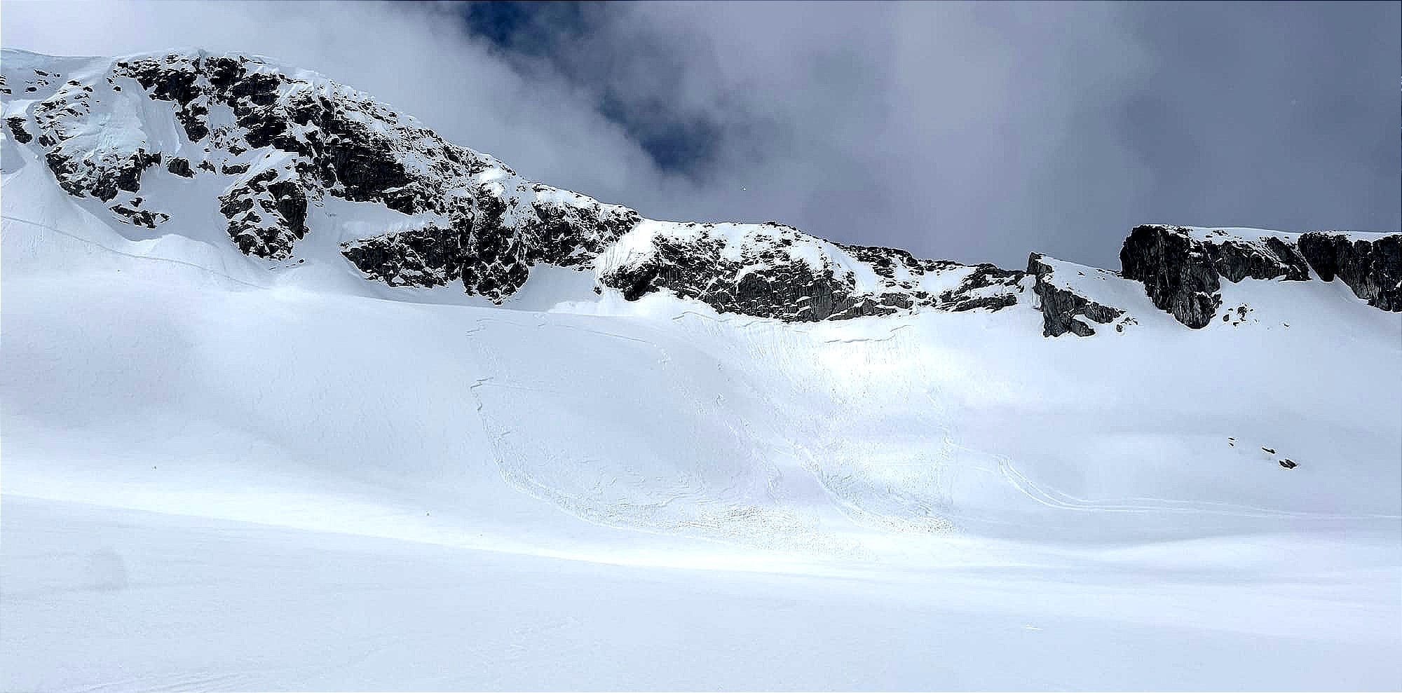
Thursday was clear and cold overnight into a beautiful blue day. Very tempting to go big with nice cold, dry snow. While avalanche hazard had dropped to Moderate, we immediately dialled back our expectations and set a rule to stick to as sheltered of terrain as possible (where wind slabs were less likely to build), and avoid unsupported slopes. By the end of Thursday, a ton of reports of human triggered avalanches had come in. Aussie Couloir, Saucer Chute, East Face of Trorey, Million Dollar Couloir, and many more. Lots of aspects and many areas throughout the corridor. All slabs failed on the April 14th crust. Generally the destructive size was 2 or less. By Thursday, reports of natural avalanches had tapered off.
Friday and Saturday got progressively warmer but also had a bit of wind to affect the snow surface and perhaps contribute a bit more to slabs. The avalanche hazard was Moderate. Reactivity continued with significant slides on Slalok Stonecrop Face as well as the Matier Icefall access. By Saturday, activity had tapered off - perhaps folks were getting the message about reactivity or perhaps it was just finally starting to settle with cold nights and warm days. On Sunday, AvCan increased hazard to Considerable and introduced a new Persistent Slab problem.
So what happened? Why did so many people cause avalanches? These might be some factors:
- It wasn't a classic glued-on spring storm. In fact, it seems possible that we had a setup conducive for Dry-on-Wet (DW) faceting. The warm front saturated the crust with wet rain. When the cold front passed through, the abrupt change to very cold snowfall created a large temperature gradient at the crust. There wasn't enough snowfall for a big natural cycle on Tuesday or enough to squash out and settle the weak layer so it was prime to create facets on the surface of the crust. DW faceting can happen very quickly so it's likely that we almost immediately had a persistent grain problem at the crust and that windslabs building on top became easily triggerable. Read more about DW facting here: https://arc.lib.montana.edu/snow-science/objects/issw-2004-112-120.pdf Thanks to Julie McBride for the reference!
- It's easy to think that spring avalanche hazard is mostly just wet slab and wet loose and that good timing on sunny slopes will reduce that hazard but this is a perfect example of that not being the case. While solar slopes were an issue on Thurs/Fri, it seemed like most folks were tuned into avoiding those and seeking powder instead.
- Moderate hazard is not a green light. The Conceptual Model of Avalanche Hazard has the descriptions for hazard. There's two components to the definition that a forecaster tries to line up. First likelihood of triggering: at Moderate, natural avalanches are unlikely and human triggered avalanches are possible. Considerable says natural is possible while human is likely. On Thursday, in hindsight, it felt like we fell in between the two - natural avalanches were unlikely but human triggered were likely. The second component is size and distribution: here we seemed to sit reasonably well in the Moderate definition of < Sz 2 in specific areas or Sz2-3 in isolated areas. It's easy to see how the forecast could go either way. With sparse data coming in at the end of the season, it took some time for everyone to recognize the persistent slab problem that was occurring.
Takeaways?
- The DW faceting process is one I want to be more tuned into for the future, especially in these *smaller* storms.
- Stepping out slowly is so important. After any storm, taking a day to gather info and feel how the snowpack reacts before going big.
- Using terrain to your advantage when things aren't perfect - skiing supported features and avoiding wind loaded slopes.
- Questions? Shoot us an email! Zenithmountainguides@gmail.com
What’s coming up?
Since the weekend, very warm weather has cooked off much of this new snow and slabs have settled significantly. We’re back to spring diurnal where the surface freezes during the night (as long as it’s clear) and then melts during the day.
We’re back to classic spring travel recommendations. Manage your sun exposure timing for optimal travel and avoid loose wet after lots of sun. Travel itself can be the main challenge - use ski crampons and other tools when needed!
What’s the weather forecast?
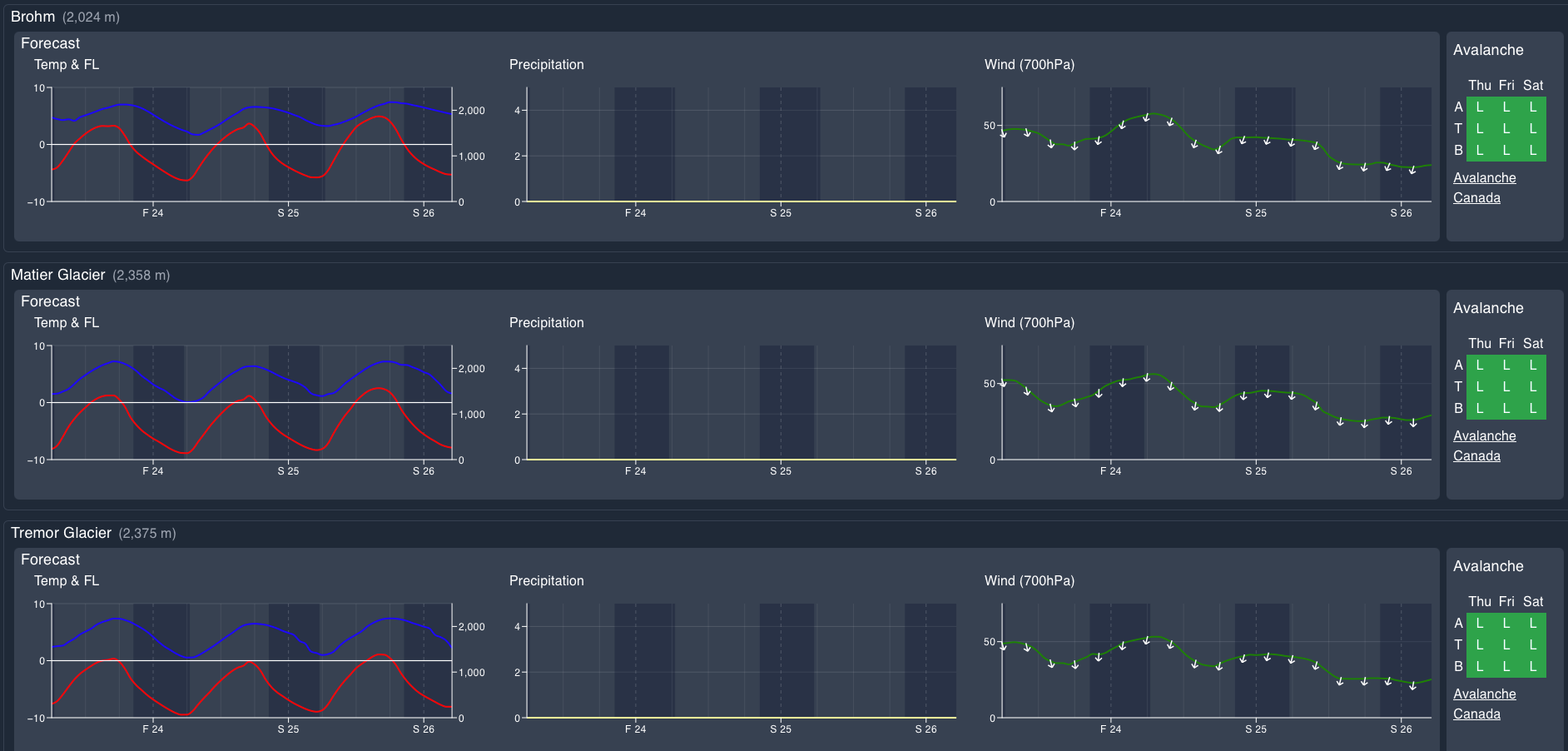
A ridge of high pressure over the coastal water of the eastern Pacific, with an upper low to the east over southern Alberta will maintain a north to northeast flow keeping conditions dry this weekend with temperatures warming, and gusty outflow winds at times.
Wind Speed:
- Friday: Northeasterly 40 gusting 70 km/h.
- Saturday: Northeasterly 40 gusting 60 km/h.
- Sunday: Northeasterly 20 gusting 50km/h.
Freezing Levels:
- Friday: 1000m morning rising to near 2000m.
- Saturday: 1000m morning rising to near 2000m.
- Sunday: 1000m morning rising to 2000m.
Precipitation: Nil…
Closing Thoughts:
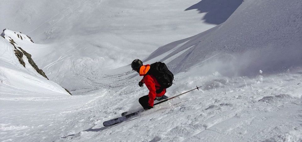
Spring has arrived! It’s corn season. There’s still reasonably accessible and awesome objectives out there if you consider your access routes and timing carefully!
For more information, check out Zenith Mountain Guides and our local avalanche forecast. Weather forecasts are custom from meteorologist Jason Ross. These updates are supported by SkiUphill Squamish - the best stop for ski touring equipment in the Coast Mountains and made possible by the Sea to Sky Gondola! Use this information at your own risk. Conditions change rapidly from when this report was written!
Member discussion