
Feb 22 - Sea to Sky Snow Conditions
Overall theme:
Are these updates feeling a bit bipolar? It’s certainly been a rollercoaster of conditions the last few weeks but we do seem to have settled into a workable pattern with a promising forecast. Most notably there is a cold front incoming!!
Where we’ve been skiing:
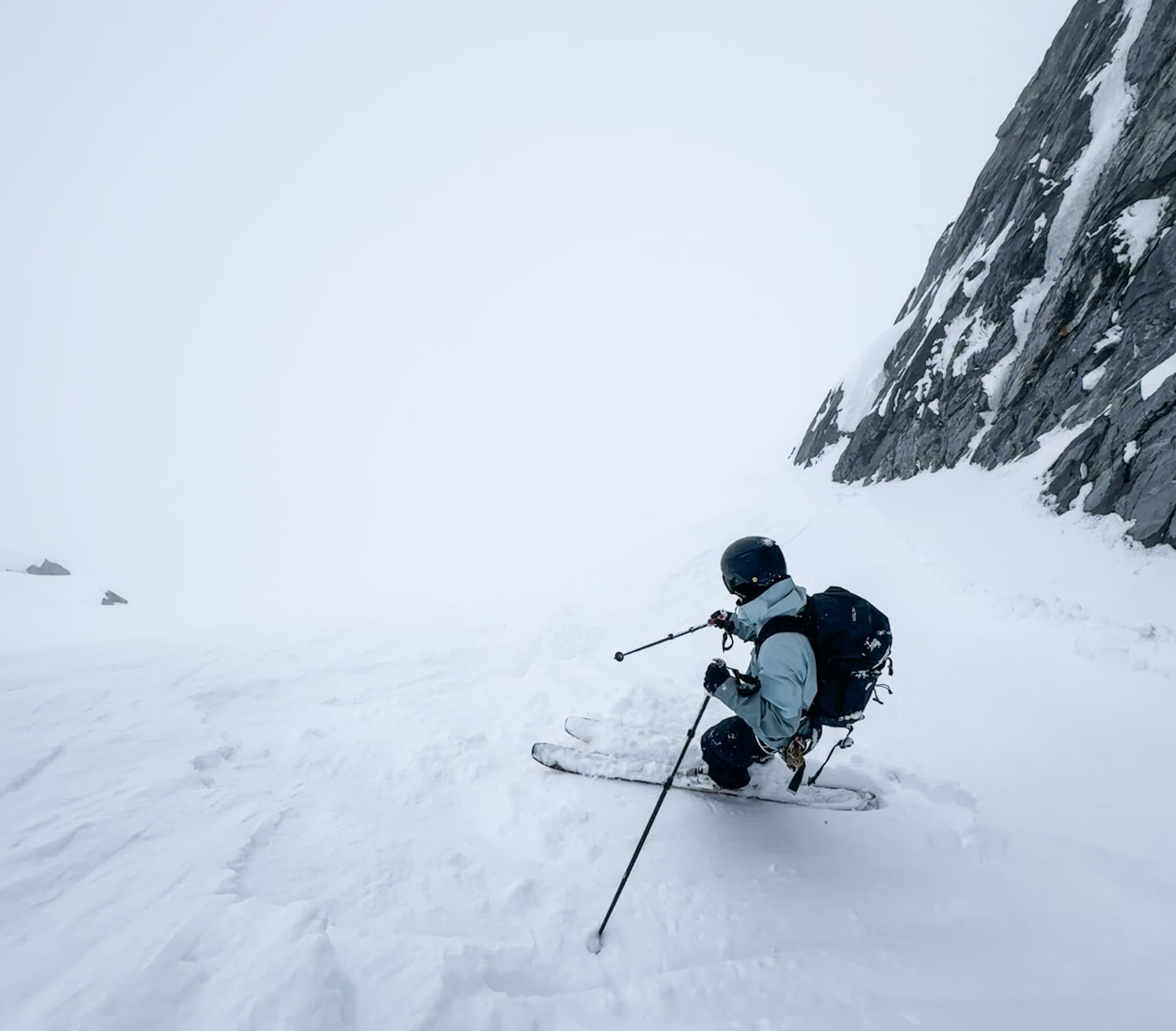
Most of our time has been around Whistler Blackcomb to be able to take advantage of the ski lifts but we’ve also explored around Birken, the central Duffey, and Squamish. The best skiing has without a doubt been in areas with the following features:
- Low angle (steeper lines have avalanche debris)
- Sheltered (avoiding wind affect - especially in the Squamish corridor)
- North aspects (less sun affect, better adherence with underlying crust)
- Just above treeline (BTL doesn’t have snow and ALP visibility can be tricky, plus these areas have reset a little better with the winds)
Not much change to access since last week. North Shore has minimal skiing. S2SG is gravel at the top station with skinnable terrain starting at 1200-1300m (Red Heather and Brohm are similar). Rubble Creek and Hanging Lake require walking to at least 1100m (spikes recommended on all the approaches). The Duffey is skiable from the car in most places but any skiing in the trees is extremely challenging. Whistler-Blackcomb is seeing lots of action but also is holding good snow! Most lines have been accessed with areas like Corona and Cham Chutes on Blackcomb and the entire Musical Bumps on Whis getting lots of traffic.
What’s happened since the last update (weather & general snowpack structure):
Relatively warm temps and minimal precip through the weekend and most of the week. Humidity stayed high and fog made visibility difficult at times. A pulse of snow came Tuesday night, providing a nice refresh. This was well timed - with few accessible areas to tour in the corridor, things were getting pretty well tracked out! Weather stayed relatively warm with strong greenhouse effect due to sun and low fog on Wednesday and Thursday, promoting fast settlement but also moistening the snow on most aspects.
We now have 5-15cm of recent snow that is sitting either directly on the crust or on 10-20cm faceted soft snow at TL or wind slab in the exposed locations over the crust. This crust overlies a very well settled mid and lower snowpack.
What’s the weather and avalanche forecast?
So everyone keeps asking us, is this the worst winter you’ve seen here? In 25 years (for Evan) I’d say sort of. The bad winters stick out in my mind and there seems to be one every 5-10 years. Ingrained in my memory is of course snow being trucked in to the north shore for the Olympics in 2010 from Mt. Baker! Are we at near record low snow depths for this time of year? Certainly. It’s grim!
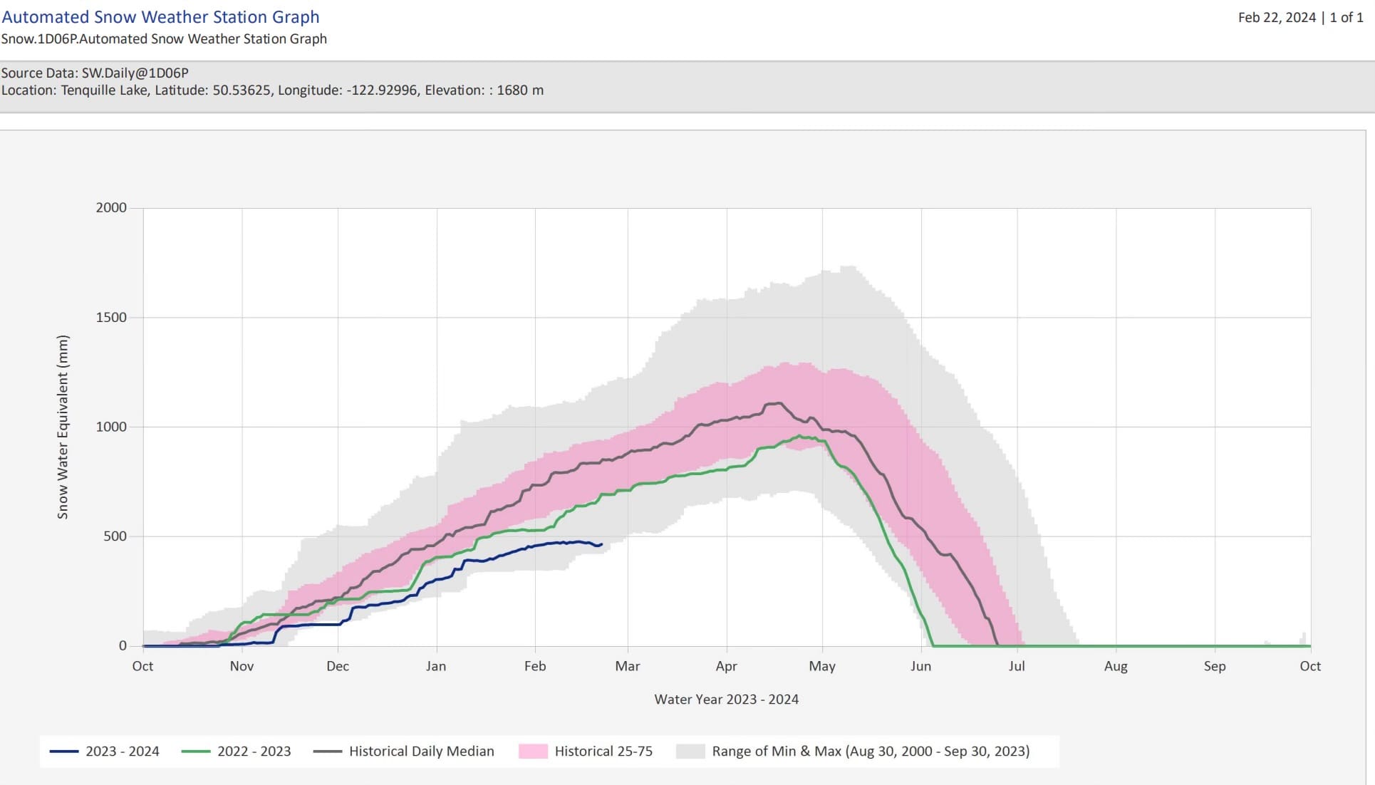
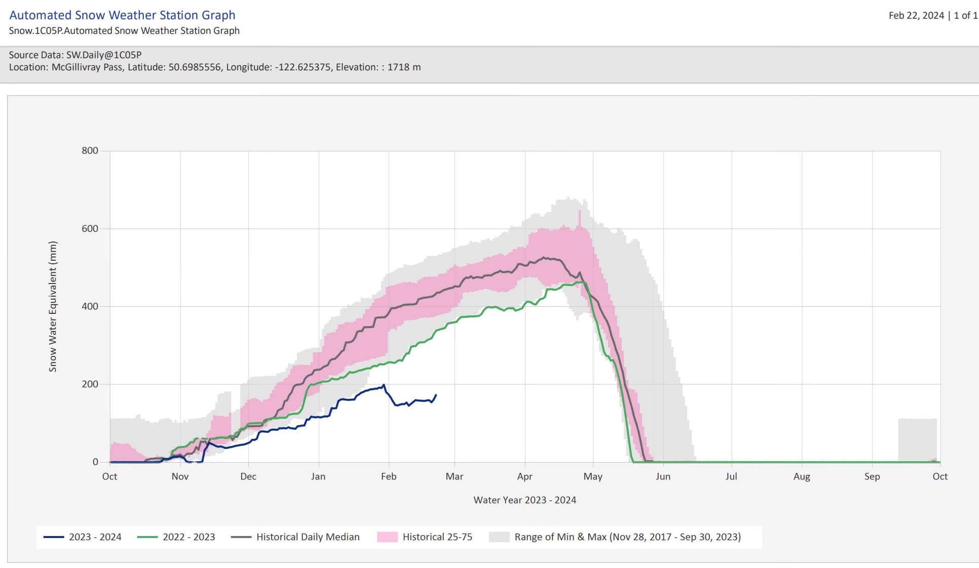
Squamish, Tenquille Lake, and McGilivary Pass snow pillows. All looking pretty bad…
But I immediately follow up this chat with everyone by saying that every single bad El Nino winters always had a really strong finish - hold out hope! Then I happened upon the PNW local meteorologist from Seattle, Cliff Mass, and his blog, confirming this as an actual scientific thing!
Don’t give up hope yet. The pattern is breaking - it’s becoming cold and wet. Model runs have been consistent and the variability is tight meaning they are all leading toward a decent amount of snow and low freezing levels. Folks also keep asking about the GraphCast/Google Deep Mind AI forecast so here’s the link.
To break it down for the next few days: Friday is the last day before a real reset…so either (GASP!) get your last trail ride in or a few pitches in the sunny smoke bluffs before we return to winter. Just being honest here, the skiing is wonderfully mediocre (Eric disagrees - skiing should always be prioritized, even when mediocre). Travel is easy, hazard is low, peaks can be bagged as long as you don’t get tangled up in tough snow on the way down.
Saturday the storm starts coming in, with FLs hovering in the 1000m range for the entire corridor. It’s coming in with a classic SW flow as well. 5-15cm expected through the day with light to moderate winds.Sunday is the brunt of the storm with 20-30cm of new during the day and moderate to strong winds from the SW with FL still around 1000m, slightly lower for snow levels as the precip will be intense. Then a sharp frontal passage dropping FL to valley bottom! The storm track looks to continue with good precip mid-week and a zonal flow with low FL’s.
Avalanche Canada has the hazard rating at 2-2-1 through Saturday before spiking to 4-3-2 on Sunday. Residual windslabs maybe be growing through Saturday but Sunday is where we expect to see natural activity pick up significantly!
What are my questions for the weekend?
- Will the classic set up of coming in warm and finishing cold be even close to enough to deal with our upper snowpack facets/crust combos? This is a terrible snowpack set up and we will dive a little deeper below.
- What will we expect for the intensity of the storm on Sunday? How much precip, how much wind, and what will the FLs be? At the moment it looks like we’ll get a pretty classic storm with ~30cm, moderate to strong southerly winds, and freezing level around 1100m. Not enough to save the BTL skiing but certainly will help our access!
- Will there be an avalanche cycle during the storm that flushes out some of the instability or will we see storm/wind slabs loaded up for Monday/Tuesday? And if it starts storming huge will we even know?
- Looking further into the week - will we continue to see precip as the week goes on?
What will I watch out for or avoid completely?
- For the weekend, visibility and quality will be huge limiting factors. Be warned - there are a ton of old tracks, tough surfaces, open creeks, debris, etc… hiding at treeline. Low vis with new snow will make it tricky in the short term.
Closing Thoughts:
We’ve got a good chance at closer to seasonable conditions and an improvement in our coverage and ski quality coming this week! It’s possible we’ve gotten a little complacent with the relative stability we’ve had over the last couple weeks and with a major change in weather, we should be cautious. We’ll be back to an assessment mindset during this series of storms before we move to stepping out!
To further elaborate, we had a good conversation about how bad our avalanche problem might become in the next short while. The melt freeze crust is everywhere and its stout. We are getting lucky right now because it got really warm Wed/Thur with a warm start to the storm. This is a classic coastal scenario and often sees us through these weak layers well. But it will take a bit of time, avalanche cycles, and healing to build up our confidence after the snow starts falling. We aren’t in the typical late winter pattern of waiting 24 hours and then shred away. As my (Evan’s) mentor Bruce Tremper ingrained in my psyche - weird weather means weird avalanche cycles. We’re playing the long game here at Zenith and if this winter has not taught you patience for skiing, then you will never learn!
Eric Carter and Evan Stevens contributed to this report. For more information, check out Zenith Mountain Guides and our local avalanche forecast. These updates are supported by SkiUphill Squamish - the best stop for ski touring equipment in the Coast Mountains and made possible by the Sea to Sky Gondola! Use this information at your own risk! We are not responsible for your actions in the backcountry and conditions change rapidly from when this report was written!
Member discussion